


SITKA, ALASKA
Lt. Collin Bronson, the executive officer of the Maple, says his crew was eager to get the buoy working again before the beginning of the summer fishing season.
“It’s a very important buoy. It’s important to Sitka; it’s important to us. We saw a window and we took it. We coordinated with the guys down in the gulf at the National Data Buoy Center, the NOAA folks, and got them to come up, picked up the buoy, brought it in, and made the necessary repairs, and then put it out. So we’re very happy to report that it is operating properly.”
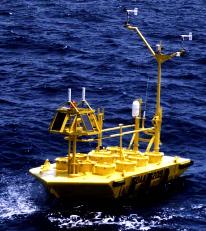
The Cape Edgecumbe buoy is not a regular Coast Guard buoy, or aid to navigation. Station 46084, as it is formally known, is one of four data buoys positioned on the continental shelf between Cape Suckling and Dixon Entrance, and one of at least two-dozen deepwater weather buoys in the Gulf of Alaska. The offshore buoy system is operated by the National Data Buoy Center at the Stennis Space Center in Mississippi. The NDBC itself is a part of NOAA, or the National Oceanic and Atmospheric Administration.
But the NDBC couldn’t function without the help of Coast Guard ships like the Maple. Bronson says the Edgecumbe buoy is the size of a small boat.
“It’s huge, several thousand pounds. What’s more remarkable about these NOAA buoys as opposed to the ones you see in the harbors or the channel markers is that the mooring – the length of line, chain, and sinker – is so incredibly deep. You’re talking 10,000-feet deep in some cases. It’s so far offshore, so remote. The Cape Edgecumbe aid is 35miles offshore. That’s a long haul to work a buoy. The sea state that you see in Sitka is nowhere near what you’re going to get 35 miles offshore. But some of these aids are 600 miles offshore and it takes quite a bit of planning and logistics.”
There’s so much line holding the Edgecumbe buoy to its mooring on the ocean floor that the line itself has to be supported with floats. In 2008, in a fierce winter storm, the Edgecumbe buoy’s mooring parted and was unrecoverable. The buoy itself drifted north and west, finally coming ashore 400 miles across the Gulf of Alaska near Kayak Island at Cape St. Elias.
That time, the Maple had to replace the entire mooring. This job, says Bronson, was a bit easier.
“It was nice that we were able to salvage and recycle the mooring. That’s 10,000 feet or so of nylon line, shackles, chain, and sinkers. And what we were able to do was detach the weather buoy, and in its place put a large, 8 x 26 foot navigational aid, just to hold the mooring in place while we went and fixed the aid. And then we were able to swap it again. So it was really nice that we were able to save that mooring because oftentimes what will take the longest in working a weather buoy is deploying that mooring. When you’re putting out that much line it takes hours.”
The hours and days spent replacing the Edgecumbe buoy are a striking contrast to some of the Maple’s other work. Bronson says that the ship also found time this spring to work on the number 8 red buoy in Sergius Narrows, which had fouled on the bottom and was being pulled under in high flood tides.
Bronson says you rarely see the combination of narrow channel, shallow draft, and fast current that is typical in Sergius. The window of opportunity to work on the buoys in the channel begins about a half-hour before slack water.
“The ship can do some amazing things, but you’re really pushing it to its full capability when you’re working a buoy like the Sergius buoys.”
Bronson says that the time the Maple spends in Sergius depends on the job. Sometimes the ship pulls a buoy at slack tide, cuts the chain, and will reset it on the following tide.
© Copyright 1970, Raven Radio Foundation Inc.


