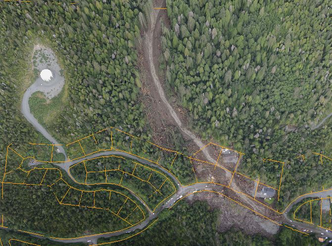
A screen capture of a 3-D image of the Kramer Avenue slide area, from data produced by the state Division of Geophysical Survey. (3-D image Joshua Houston/City & Borough of Sitka)
One month after a deadly landslide struck in Sitka, a group of scientists and agency officials are starting the complicated task of learning what happened. The Geo Task Force has been meeting informally at the Sitka Sound Science Center. The center’s director, Lisa Busch, believes these gatherings are an important first step in understanding the area’s geophysical hazards.
The most troubling aspect of the August 18 slide in Sitka is that it seemed so random. Sure, it was raining hard — but it often rains hard here. What exactly made this day different than thousands of other days? What made a single address on Kramer Avenue so hazardous?
The answer is literally a puzzle, and everyone’s holding a different piece.
“It’s the Forest Service, it’s the USGS (US Geological Survey), it’s the Forest Service, it’s University of Alaska Southeast, University of Alaska Fairbanks, NASA, the National Park Service, the City of Sitka, the Sitka Conservation Society, the Alaska state Department of Natural Resources Division of Geologic Survey — who am I forgetting?”
Sitka Sound Science Center director Lisa Busch says the Geo Task Force began with a phone call to the Geophysical Institute in Fairbanks, and took off from there. The Geo Task Force is a long way from providing any answers. Right now they’re working on framing the question.
“So we got these groups together, and the idea has been to try and figure out what we know, and what needs to be known.”
So what is it that we know? Busch says there was a geophysical study of the area prior to the slide, and some additional work in the aftermath. But the information is pretty basic.
“So we know that it was 12 acres. We know the slide was about 1,000 feet. There have been several different flights around the slide area and up to West Chichagof. The National Weather Service says that this was a 50-75 year rainfall event that happened during high winds. We don’t know yet exactly how it happened. We don’t know all of the information to say what exactly the cause is yet.”
The Geo Task force has some exceptional tools at its disposal. A private satellite company took high-resolution imagery of the slide area; Busch says the National Park Service is working on acquiring that data. The state Division of Geophysical Survey generated data that allowed Josh Houston, a cartographer in city hall, to produce amazing 3-D orthoimagery of the slide that allows viewers to examine the slope in remarkable detail.
And then there’s just serendipity, in the form of the National Aeronautics and Space Administration.
“NASA was coming to Alaska anyway to try out an experimental technology — AirMOSS — in which they could measure the movement of the ground through the vegetation, and they could also measure moisture in the soil. And they were coming anyway to look at permafrost issues. And the timing of this was they were coming to Alaska anyway, Hey, we can change our flight plan and fly over Sitka. They’ve done that twice.”
Busch says there’s a chance that NASA will incorporate the Sitka landslide study into its Alaska AirMOSS experiment.
NASA is also funding a research collaboration between the National Weather Service and the University of Alaska Southeast on landslide predictability. Busch says the work so far has been a statistical correlation between rainfall events and slides, and would produce forecasts for a general area, rather than individual neighborhoods.
It also doesn’t factor in Sitka’s unique surface geology.
“Most of us in Southeast Alaska know that we have glacial till, mixed with ash, mixed with a lot of rainfall. And that is a pretty brutal combination in terms of causing landslides.”
Busch says that she’s excited by the energy of the Geo Task Force. She believes the scientists and academics are driven by a strong desire to help the community learn as much as they can about the geophysical mechanisms behind these slides.
What the Geo Task force is not going to do is tell us where it’s safe to live — not yet.
“There’s a difference between risk assessment and knowing where the hazards are, and that’s a whole other set of people, a different set of expertise. So what we do with that hazard survey information is kind of the next question for policy makers.”
Busch has lived in the community for a long time. She says she loves the mountains and the rainforest. The August 18 slide was a reminder that we live in this remarkable place at the mercy of forces beyond our control. For Sitkans looking for answers, Busch counsels patience and study.
“To find some kind of understanding out of this tragedy. And I don’t know if this going to help us feel a little less powerless. We think at the Science Center than knowledge is some kind of power. So if we can get a little more information about the area, we’ll feel a little bit more at ease.”


