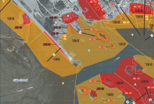
FEMA is developing a multi-hazard risk map for Sitka. Draft maps are now available for flood risk. At tonight’s meeting (01-25-17), property owners and residents will have a chance to learn about the flood mapping process and what the changes mean for them. (Map courtesy of FEMA)
Sitka property owners can get a bird’s eye view of flood risk tonight (01-25-17).
The Federal Emergency Management Agency (FEMA) and the State of Alaska Department of Commerce, Community, and Economic Development will hold a public meeting to unveil preliminary maps of flood risk along Indian River, Swan Lake, and 32 miles of city-owned coastline. These maps have been refined with LIDAR data collected over the summer.
The mapping project began in 2013, when FEMA committed to developing a multi-hazard Risk Report for the Sitka area. The report will be published this summer, and will integrate risk assessment for earthquakes, erosion, landslides, and tsunamis.
At tonight’s event, the focus will be on flooding and the current risk of a “base flood event.” That’s a map depicting what a 1% annual chance of flooding would look like in Sitka. State and federal representatives will be on hand to take questions about how these maps impact property. In the long term, the maps will be used to determine where the purchase of flood insurance is required by federally-backed mortgages.
In a press release, the City and Borough of Sitka stated that homes in high risk areas have a 26-percent chance of incurring flood damage over the life of a 30-year mortgage. The risk of fire damage, in comparison, is 9%.
The meeting begins at 5 p.m. tonight in Harrigan Centennial Hall.
All of FEMA’s draft maps are available for viewing at City Hall or online here. Click here to learn more about federal flood insurance.


