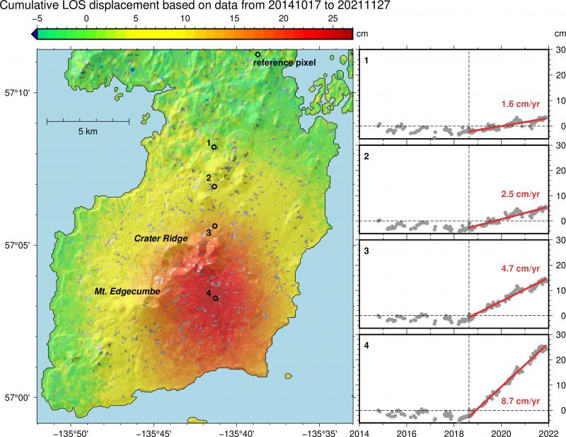
The Alaska Volcano Observatory on Friday (4-22-22) released new information which appears to confirm that the recent earthquake “swarm” under Mt. Edgecumbe (4-11-22) is the result of volcanic activity, rather than the background tectonic activity of the Queen Charlotte Fault.
An analysis of satellite radar data over the last year shows significant uplift over an 11-square mile area just east of the Mt. Edgecumbe crater — totaling almost 11 inches. The deformation has been occurring at a steady rate of over 3 inches per year since 2018, and “there has not been an increase with the recent earthquake activity.”
The AVO offers this prognosis on the situation at Mt. Edgecumbe:
The coincidence of earthquakes and ground deformation in time and location suggests that these signals are likely due to the movement of magma beneath Mount Edgecumbe, as opposed to tectonic activity. Initial modeling of the deformation signal shows that it is consistent with an intrusion of new material (magma) at about 5 km (3.1 miles) below sea level. The earthquakes likely are caused by stresses in the crust due to this intrusion and the substantial uplift that it is causing.
Intrusions of new magma under volcanoes do not always result in volcanic eruptions. The deformation and earthquake activity at Edgecumbe may cease with no eruption occurring. If the magma rises closer to the surface, this would lead to changes in the deformation pattern and an increase in earthquake activity. Therefore, it is very likely that if an eruption were to occur it would be preceded by additional signals that would allow advance warning.


