Planners are looking for public input on a new master plan for Mt. Edgecumbe High School.
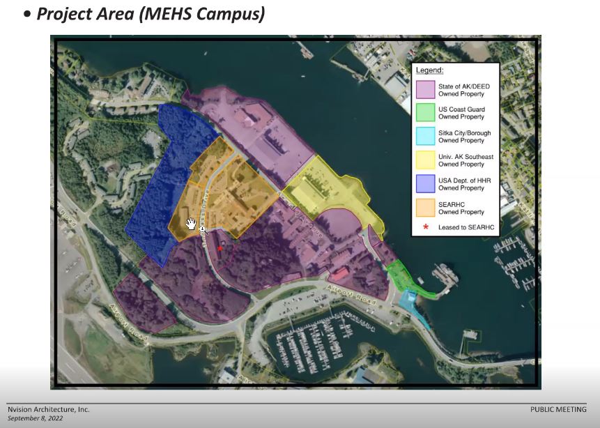
The state-owned boarding school has far more land than its buildings occupy on Japonski Island in Sitka, and lately there’s been pressure from neighboring property owners hoping to expand.
Architects and state officials met with stakeholders in a public meeting on September 8 to gather input that could help shape the vision for the school – and they’re hoping for more input over the week.
Land use at Mt. Edgecumbe recently came under the spotlight, when the State Board of Education agreed to enter negotiations with the Coast Guard for the purchase of some of the school’s waterfront property. Board members wanted the sale to conform to the Mt. Edgecumbe Master Plan, but the first planning meeting wasn’t scheduled until the day after the board met in Sitka on September 7.
Still, the Coast Guard request is a fraction of the Department of Education’s footprint on Japonski Island. The Southeast Alaska Regional Health Consortium is another major property owner, and there is both City of Sitka and other federal property.
Tim Mearing, the facilities manager for the state Department of Education and Early Development, said he had personally been involved in three previous master planning efforts for the school, but this time around there were some new things happening.
“One of which is this public involvement piece,” said Mearing. “We’ve never really done this before, for our master plan at the school, and so it’s an exciting step for us to put that in.”
The planning meeting was facilitated by Anchorage-based architect Paul Baril, along with Chris Mertl, a landscape architect in Juneau. Baril said the goal was to incorporate as much information into a visual tool to help guide development of the school.
“The long term plan for this project is to have a completed 3D map of the campus that will be a database for the Department of Education and Mt. Edgecumbe to use not only as a wayfinding tool, but also as a database for all of this information that we’re gathering through this master plan process,” Baril said.
A draft master plan and mapping website would come on top of a detailed analysis of building conditions, and be ready by the end of October.
In the meantime, planners want public input. Attendees at the meeting provided ideas and priorities for the group, with suggestions ranging from incorporating more Native foods into the school’s meal plan, to focusing on place-based learning, teacher housing, and resisting pressure to sell land.
The Mt. Edgecumbe Master Plan has its own website, where a recording of the September 8 meeting is available. The public comment period was expected to be open for two weeks.


